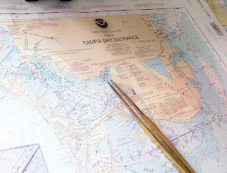
If you are planning a trip over the oceanby boat, you must have a sea chart and know how to read it. Sea charts represent coastal regions and depths that you will reference as you travel.Think of your sea chart as an aquatic map.

- Look for the directional symbols on the sea chart. A typical sea chart should displaythe word "North" or the symbol "N" with an arrow pointer next to it. This is the direction of North on your chart.
- Learn what the colors on the sea chart signify. Blue on the sea chart typically indicates. Brown or green indicates land.
- Find where you are on the sea chart. The land portion of the sea chart displays different landmarks, cities and different major power cables that you can reference to determine your location.
- Examine the water depths. The numbers on the water in the sea chart show the depth from the water level to the base of the sea. Compare these numbers with the depth your boat typically enters in the water. You want the depth of the water to be deeper than your boat.
- Locate your starting position on the chart, and then trace your route. This makes it easier for you to use the chart when you need it.
- Locate hazards on your sea chart before you sail so that you will know which locations to avoid.
Remember:
- Sea charts often become outdated quickly. Make sure your charts are current.


